Coordinates
| This article needs to be updated to match TFC+'s newest version. It might not contain completely accurate information for the newest version. Please help by contributing.
|
| This page needs to be updated for the newest version of TFC+. The content described on this page may no longer be relevant in the newest version of TFC+.
|
Contents
Displaying Coordinates
Pressing F3 (or Fn+F3 on Macs and some laptops) brings up a debug screen with various data—including your current coordinates, at the top left of the screen.
Interpreting Coordinate Numbers
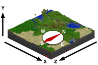
Coordinates numerically represent your location in a Minecraft world. They are based on a grid where three lines or axes intersect at the origin point.
- the x-axis indicates the player's distance east (positive) or west (negative) of the origin point—i.e., the longitude,
- the z-axis indicates the player's distance south (positive) or north (negative) of the origin point—i.e., the latitude,
- the y-axis indicates how high or low (from 0 to 255, with 140 being sea level) the player is—i.e., the elevation,
thereby forming a right-handed coordinate system (thumb=x, index=y, middle=z), making it easy to remember which axis is which. It can be said that z=0 is the equator. Rainfall is partially determined by distance from the equator in the Z-axis.
Additionally, the f number in the debug screen tells you which direction the player is currently facing. 0 equals due south. Thus:
- 0 = South
- 1 = West
- 2 = North
- 3 = East
The origin point marks the zero point for the x and z coordinates. Hence, it may be thought of as the 0,0 coordinate:
- x-axis = 0
- z-axis = 0
As you travel south, the z-axis number increases; travel north and it decreases. Similarly, the x-axis number increases as you travel east and decreases as you travel west.
One coordinate number equals one block. And, in terms of real-world measurement, one block equals 1 cubic meter.
As your elevation rises, the y-axis number increases, and as your elevation lowers, that number decreases.
Coordinate Usage
Coordinates may be put to a variety of uses.
Once players establish bases, they should note their coordinates before going exploring. If they get lost or respawn they can find their way back to their bases by walking to those coordinates.
Coordinates are often used when sharing level seeds to give directions on where to go to find things.
Latitude
Ambient Temperature, the apparent position of the sun (and its rising and setting), and other Climate calculations, such as Rainfall, are based on the given latitude (Z coordinate) of an area. The line of Z = 0 is considered the equivalent of Earth's equator, while the line of Z = -30,000 is considered roughly equivalent of Earth's arctic circle. With this scale, it can be assumed that for every 1,000 blocks the Player travels north/south is roughly equivalent of travelling about 250 km on Earth.
Using these numbers, the following equation can be used to calculate a rough comparison of location in the game, to an area on Earth (Northern Coordinates Only):
((Z / -1,000) * 250) / 10,002 * 90 = Degrees North.
The value obtained through using this calculation can be interpreted such that the average temperature of this area will be similar to the same latitude in degrees north of the equator in a continental (i.e. non-coastal) location of North America. This results in world generation similar to that of the real world, with deserts near the equator, and arctic near the poles. Please note that coastal climate change is not considered in these equations, so it is extremely possible to have a desert area in game that has a location which points to a rainforest on Earth using the equation.
For example, a Z coordinate of -15,000 results in the following value
((-15,000 / -1,000) * 250) / 10,002 * 90 = 33.74 Degrees North.
This coincides with the general idea of a Z coordinate of around -15k being a similar climate to that of the United States.
The same calculation can be done for southern coordinates and degrees south by simply dividing by positive 1,000 instead of negative.
Longitude
Longitude does not affect anything.
